


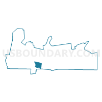
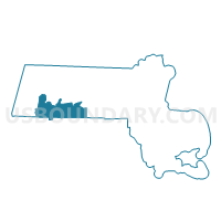
Southwick Precinct 3, Hampden County, Massachusetts
About
Outline

Summary
| Unique Area Identifier | 594201 |
| Name | Southwick Precinct 3 |
| County | Hampden County |
| State | Massachusetts |
| Area (square miles) | 8.33 |
| Land Area (square miles) | 8.30 |
| Water Area (square miles) | 0.03 |
| % of Land Area | 99.65 |
| % of Water Area | 0.35 |
| Latitude of the Internal Point | 42.06683850 |
| Longtitude of the Internal Point | -72.73865490 |
Maps

Graphs
Select a template below for downloading or customizing gragh for Southwick Precinct 3, Hampden County, Massachusetts


Neighbors
Neighoring Voting District (by Name) Neighboring Voting District on the Map
- Agawam Precinct 2, Hampden County, MA
- Agawam Precinct 7, Hampden County, MA
- Southwick Precinct 1, Hampden County, MA
- Southwick Precinct 2, Hampden County, MA
- Suffield 1 Voting District, Hartford County, CT
- Westfield Ward 5 Precinct A, Hampden County, MA
- Westfield Ward 5 Precinct B, Hampden County, MA
Top 10 Neighboring County Subdivision (by Population) Neighboring County Subdivision on the Map
- Westfield city, Hampden County, MA (41,094)
- Agawam Town city, Hampden County, MA (28,438)
- Suffield town, Hartford County, CT (15,735)
- Southwick town, Hampden County, MA (9,502)
Top 10 Neighboring Place (by Population) Neighboring Place on the Map
Top 10 Neighboring Unified School District (by Population) Neighboring Unified School District on the Map
- Westfield School District, MA (41,094)
- Agawam School District, MA (28,438)
- Suffield School District, CT (15,735)
- Southwick-Tolland School District, MA (9,987)
Top 10 Neighboring State Legislative District Lower Chamber (by Population) Neighboring State Legislative District Lower Chamber on the Map
- Third Hampden District, MA (41,281)
- Fourth Hampden District, MA (41,094)
- State House District 61, CT (24,674)
Top 10 Neighboring State Legislative District Upper Chamber (by Population) Neighboring State Legislative District Upper Chamber on the Map
- Second Hampden & Hampshire District, MA (156,603)
- Hampden District, MA (155,199)
- State Senate District 7, CT (100,005)
Top 10 Neighboring 111th Congressional District (by Population) Neighboring 111th Congressional District on the Map
- Congressional District 2, CT (729,771)
- Congressional District 2, MA (661,045)
- Congressional District 1, MA (644,956)
Top 10 Neighboring Census Tract (by Population) Neighboring Census Tract on the Map
- Census Tract 8132.05, Hampden County, MA (7,481)
- Census Tract 8126, Hampden County, MA (6,799)
- Census Tract 8131.01, Hampden County, MA (5,888)
- Census Tract 8129.02, Hampden County, MA (4,802)
- Census Tract 8131.02, Hampden County, MA (3,614)
- Census Tract 8132.04, Hampden County, MA (3,240)
- Census Tract 4772, Hartford County, CT (2,955)